
GPS track counter-clockwise around the marsh island.
(I must have lost the signal near the end--I didn't paddle straight overland!)
The weather forecast in Eastham had improved overnight: partly-sunny with light winds. But I only discovered this late Friday morning. I'd have to be quick to take advantage of a rising tide. I got the car loaded and kayak on the roof and set off just after noon.
Almost ready to push off in Salt Pond, I realized I'd forgotten paddles! Plan B was to forget paddling Nauset Marsh and go for a walk. Unacceptable. Plan C was to buy a paddle--and quick. Half an hour later I pushed off, proud owner of a brand-new used one-piece paddle at a fairly exorbitant price.
It was now 2:30pm and the tide was high--a moon tide, since the full moon was just a day or two past. I was already acquainted with the strong current that pours toward the inlet on a falling tide. But I'd fought my way back the last time. Also, the current probably wouldn't be that strong if I avoided the outer marsh.
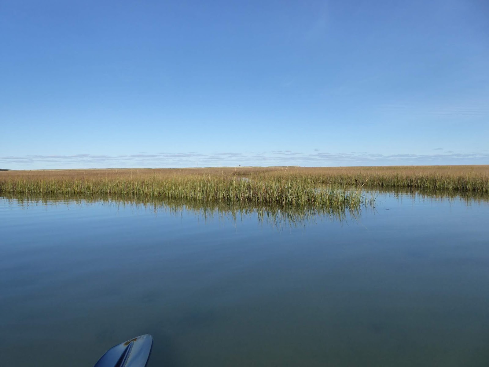
I struck straight out, with a vague idea of heading up into the northern part of the marsh near the old Coast Guard station--and well away from the inlet. A distant object caught my eye--likely an osprey nest platform--and I headed for it.
The flat, uniform marsh terrain fools the eye. From my vantage point only a few feet above the water, it was difficult to judge the distance to marsh grass. All at once I nearly ran into marsh grass that only minutes ago I'd thought a mile off.
When I came to a large marsh island, I thought I'd make a quick circumnavigation, and headed south along the marsh bank. Minutes later a deep channel wound into the marsh, beckoning. I headed into it, going deeper and deeper, following first one fork and then another. Other channels as well as disconnected ponds were visible off in the marsh grass. I found my way out again and continued my circumnavigation.
In several places I could see that the edge of the peat had collapsed into the channel, drowning the plants that grew on it. If this continues, the area of the marsh must decline and the open water increase. With sea level rising, I wonder if this chipping away inside and out will be the thing that dooms Nauset and others salt marshes?
Other channels appeared, and I followed them, mapping the channels with the gps track on my phone. Again, navigation was tricky since the channels wound and branched, narrowing gradually until I couldn't turn around, but must back the kayak up some distance. I was eventually rewarded by reaching the distant osprey platform, which held a sizeable nest of sticks from past seasons. In the confusion of branching channels, I once resorted to gps to insure I wasn't going in circles.
It isn't that I wasn't aware of the growing risk during my exploration, just that the danger seemed a little diffuse, and I could always justify pushing my luck just a little farther.
But all at once the sight of current flowing cross-wise through the marsh--following no channel I could see--brought me up short. I needed to cover distance quickly, and from then on ignored the channels that opened before me. I was clearly circling a large marsh island, which would bring me quite near to the inlet. The strengthening current gave me quite a ride as long as I was paddling with it--I later found my gps recorded a top speed in excess of 6 mph. All at once I turned a corner and found myself paddling across the current. I made good progress, and decided I would be able to get well away from the inlet before needing to turn up-current; at such a distance the current would be more manageable.
Relaxing a bit with the conviction that I had passed the inlet (which I imagined shielded from view by marsh grass) I got a bad surprise: the inlet was ahead rather than behind, and I would need to pass uncomfortably near it. The water pouring out made an impressive spectacle as it collided with waves coming in off the Atlantic. That I couldn't imagine stopping to photograph it, or the gray seals whose heads popped up around me, tells you how worried I was.
The bank turned again, and now I was going up-current. My furious paddling produced a fairly impressive bow wave, yet the marsh grass on the adjacent bank seemed to be passing one blade at a time. With every moment the current was likely to strengthen, yet that same current delayed my progress toward safety.
The water shallowed in places, and my paddle hit sand on nearly every stroke. Over and over I ran lightly aground on a sandbar that had current streaming over it. It was painful to have to backtrack to get into deep enough water, but the longer I remained grounded, the less water would remain to float me. I finally noticed that smoother, less turbulent water indicated depth. Muscles working but mind idle, I formed a back-up plan: if it seemed the current would win, I could nose the boat into some part of the marsh or beach it on sand and wait until the tide turned at about 8:30pm, and water gradually returned to the marsh. It would be a cold, dark wait, but I was warmly-dressed and had more warm clothes in a dry bag. I didn't think too hard about how I would navigate the marsh in the dark; time enough for that later.
Gradually the current I was fighting lessened. I was able to photograph a few birds, and to stop and think for a minute. Then it occurred to me that there was no guarantee of enough depth of water on this side of the marsh island to paddle back to Salt Pond where I had launched. But the Nauset Marsh Trail ran nearby, and led to Salt Pond. I would probably be able to carry kayak and gear along the trail by shifts, but it would be long, hard work.
In the end, there was still water enough--I didn't wait around to see how low the water might get this moon tide. I paddled briskly back into Salt Pond, happy to be making progress more proportional to my effort, and touched the beach at 5pm. A satisfying adventure completed.
Of course I'd never allow myself to be led down this particular primrose path again, right?

Fully-loaded, but no paddle!

Skiff makes a nice photo. Wind must be from the north.

Distance is hard to judge: is the nearest marsh ahead a hundred yards away, or a thousand?

Oh--a hundred!

The old Coast Guard station is just north of the marsh and above Coast Guard Beach.

Osprey nest platform--is it on the outer beach, or in the marsh proper?
Following channels into the marsh.


The osprey nest platform turns out to be near the middle of the marsh island.


I disturbed a conclave of crows.

Finding my way out, with some relief.


(a thick-stemmed succulent looking like strings of sausages hiding among the grass in the close-up).


The outer beach in the distance.

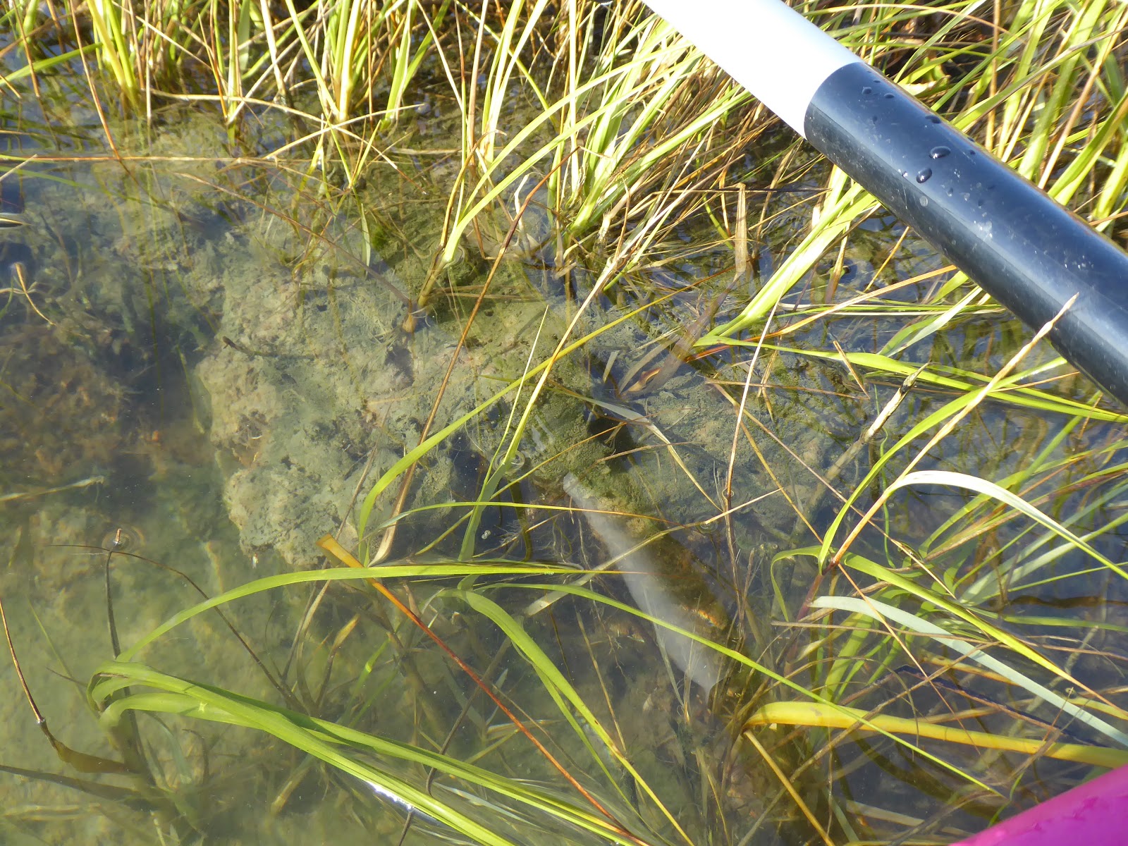
The marsh itself is made of platforms of peat with marsh plants growing out of them. The depth drops abruptly: I can be afloat in the kayak even while touching the bank with my hand.

A black duck.

A sand beach in the middle of the marsh is a curious thing.

Sand beaches are more common on the outer side of the marsh island.


Fishing floats all lean in the direction of the current. Up close, each makes a little wake.

The outside of the marsh island looks blasted and unhealthy.
Is that because it's exposed to waves that come through the inlet?

No further photos until the current slackens...

Receding tide leaves the marsh peat high and "dry."


The pressure eases enough to stop and enjoy the birds.


As the tide falls, the exposed flats become a feeding ground.

A greater yellow legs.

More of them? The jury is still out.


A greater yellow legs.


Laughing gulls.
Coming into Salt Pond.


Home.


